
|
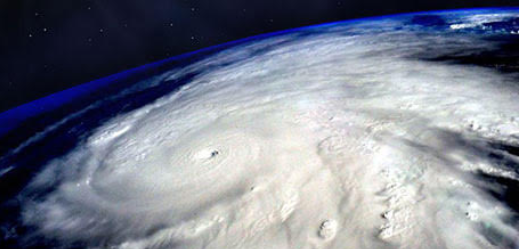
Category 5 on the Saffir-Simpson hurricane scale has no upper bound, on paper. But in theory, winds from a powerful hurricane could blow the scale out of the water, scientists say. There is no such thing as a Category 6 storm, in part because once winds reach Category 5 status, it doesn't matter what you call it, it's really, really, bad. The scale starts with a Category 1, which ranges from 74 to 95 mph (119 to 153 km/h). A Category 5 storm has winds of 156 mph (251 km/h) or stronger. An extrapolation of the scale suggests that if a Category 6 were created, it would be in the range of 176-196 mph. 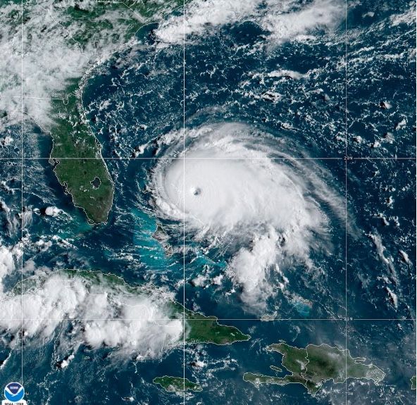 Hurricane Wilma, in 2005, had top winds of 175 mph (280 km/h). And as of Tuesday morning (Sept. 5, 2017), Hurricane Irma's winds were raging at a whopping 175 mph (280 km/h) as well, with the potential to strengthen, according to the National Hurricane Center, part of the National Oceanic and Atmospheric Administration (NOAA). Irma is churning about 270 miles (440 kilometers) east of Antigua and 280 miles (445 km) east-southeast of Barbuda, the NHC says. [A History of Destruction: 8 Great Hurricanes]
How much faster could hurricane winds blow? A hurricane gains strength by using warm water as fuel. With Earth's climate warming, oceans may grow warmer, too. And so, some scientists predict, hurricanes might become stronger. Particularly, researchers have found the strongest storms should become even more intense as the planet warms, Live Science previously reported. By the end of the 21st century, human-caused global warming will likely increase hurricane intensity, on average, by 2 to 11 percent, according to a review by NOAA's Geophysical Fluid Dynamics Laboratory, revised on Aug. 30, 2017. But physics dictates there must be a limit. Based on ocean and atmospheric conditions on Earth nowadays, the estimated maximum potential for hurricanes is about 190 mph (305 km/h), according to a 1998 calculation by Kerry Emanuel, a climatologist at the Massachusetts Institute of Technology. This upper limit is not absolute, however. It can change due to changes in climate. Scientists predict that as global warming continues, the maximum potential hurricane intensity will go up. They disagree, however, on what the increase will be. 200 mph or moreEmanuel and other scientists have predicted that wind speeds — including maximum wind speeds — should increase by about 5 percent for every 1 degree Celsius increase in tropical ocean temperatures. [A Guide to Hurricane Season 2017] Chris Landsea, a meteorologist at the National Hurricane Center, disagrees. After Wilma, Landsea said that even in the worst-case global warming scenarios, where global temperatures ratchet up by an additional 1.8 degrees to 10.8 degrees Fahrenheit (1 to 6 degrees Celsius), there would be about a 5 percent change, total, by the end of the 21st century. That means that hurricane-force winds are unlikely to exceed 200 mph (322 km/h), Landsea said. However, Typhoon Nancy in 1961, in the Northwest Pacific Ocean, was said to have maximum sustained winds of 215 mph (346 km/h), according to the World Meteorological Organization's Commission on Climatology, a clearinghouse for climate records set up at Arizona State University to settle the many disputes on weather and climate extremes. (A typhoon is the same thing as a hurricane, just in a different part of the world.) There are known records for wind speeds that outstrip anything ever measured in a hurricane. The fastest "regular" (or non-storm) wind that's widely agreed upon as the record-holder — 231 mph (372 km/h), recorded at Mount Washington, New Hampshire, on April 12, 1934. During a tornado in May of 1999 in Oklahoma, researchers clocked the wind at 318 mph (512 km/h). The 10 Costliest Hurricanes to Hit the US Volume 0% Fix the scale?Shortly after Wilma topped out in 2005, Emanuel called the Saffir-Simpson scale irrational, in part, because it deals only with wind, ignoring factors such as a storm's size, rainfall potential and forward speed. For instance, Tropical Storm Harvey, which made landfall in Texas as a hurricane on Aug. 25, 2017, dumped unprecedented amounts of rain on areas of the state, causing devastation in the Houston area. One rain gauge picked up more than 51 inches of rainfall, according to NOAA. "I think the whole category system needs serious rethinking," Emanuel told Live Science after Wilma. But Herbert Saffir, co-creator of the scale, countered that his scale was useful because it was simple. "As simple as it is, I like the scale," Saffir said in a post-Wilma telephone interview. "I don't like to see it too complex." Here's why no Category 6 was included: The scale was designed to measure the amount of damage inflicted by winds, and beyond 156 mph, the damage begins to look about the same, according to Simpson. Shared from https://www.livescience.com/
0 Comments
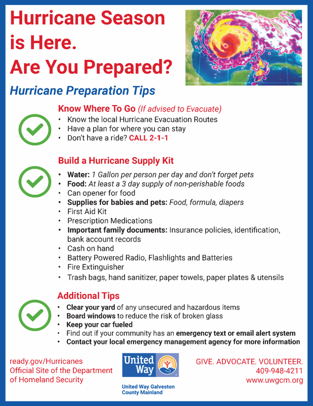
 The most important thing you can do as hurricane season approaches is to get yourself, your family and your home prepared. By starting early, you’ll avoid the rush at home supply stores, grocery stores and other venues typically crowded and often chaotic when hurricane watches and warnings are issued. You should stock six basics for your home: water, food, first aid supplies, clothing and bedding, tools and emergency supplies, and special items. Keep the items you would most likely need during an evacuation in an easy-to carry container. Possible containers include a large, covered trash container, a camping backpack, or a duffel bag. Make your preparations easier by downloading the checklists included with each category and use them as you shop and store your supplies. Food and Water[download the food and water checklist] Water
Store at least a three-day supply of non-perishable food. Select foods that require no refrigeration, preparation or cooking, and little or no water. If you must heat food, pack a can of Sterno. Select food items that are compact and lightweight. Include a selection of the following foods in your Disaster Supplies Kit:
First Aid Kit Assemble a first aid kit for your home and one for each car.
Sanitation
Include at least one complete change of clothing and footwear per person.
Special Items[download the special items checklist: infants, adults, pets] Remember family members with special requirements, such as infants and elderly or disabled persons. For Baby
In the interest of protecting pets, the Humane Society of the United States offers these tips for inclusion in your family disaster plan:
 It’s as easy as 1-2-3! Getting prepared may sound difficult or time consuming but – with a little help from the Red Cross – its actually very doable.Get a Kit Learn the essential supplies to put in your family’s survival kit. Make a Plan Plan effectively for you and your family in case of an emergency. Be Informed Understand which disasters are likely to occur in your area and what you must know to stay safe. 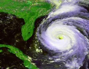 Hurricanes are the most violent storms on Earth. People call these storms by other names, such as typhoons or cyclones, depending on where they occur. The scientific term for all these storms is tropical cyclone. Only tropical cyclones that form over the Atlantic Ocean or eastern Pacific Ocean are called "hurricanes." Whatever they are called, tropical cyclones all form the same way. 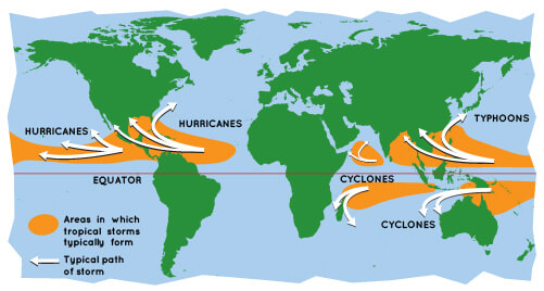  A cumulonimbus cloud. A tropical cyclone has so many of these, they form huge, circular bands. A cumulonimbus cloud. A tropical cyclone has so many of these, they form huge, circular bands. Tropical cyclones are like giant engines that use warm, moist air as fuel. That is why they form only over warm ocean waters near the equator. The warm, moist air over the ocean rises upward from near the surface. Because this air moves up and away from the surface, there is less air left near the surface. Another way to say the same thing is that the warm air rises, causing an area of lower air pressure below. Air from surrounding areas with higher air pressure pushes in to the low pressure area. Then that "new" air becomes warm and moist and rises, too. As the warm air continues to rise, the surrounding air swirls in to take its place. As the warmed, moist air rises and cools off, the water in the air forms clouds. The whole system of clouds and wind spins and grows, fed by the ocean's heat and water evaporating from the surface. Storms that form north of the equator spin counterclockwise. Storms south of the equator spin clockwise. This difference is because of Earth's rotation on its axis. As the storm system rotates faster and faster, an eye forms in the center. It is very calm and clear in the eye, with very low air pressure. Higher pressure air from above flows down into the eye. 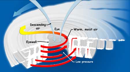 If you could slice into a tropical cyclone, it would look something like this. The small red arrows show warm, moist air rising from the ocean's surface, and forming clouds in bands around the eye. The blue arrows show how cool, dry air sinks in the eye and between the bands of clouds. The large red arrows show the rotation of the rising bands of clouds. When the winds in the rotating storm reach 39 mph, the storm is called a "tropical storm." And when the wind speeds reach 74 mph, the storm is officially a "tropical cyclone," or hurricane. Tropical cyclones usually weaken when they hit land, because they are no longer being "fed" by the energy from the warm ocean waters. However, they often move far inland, dumping many inches of rain and causing lots of wind damage before they die out completely. Tropical cyclone categories 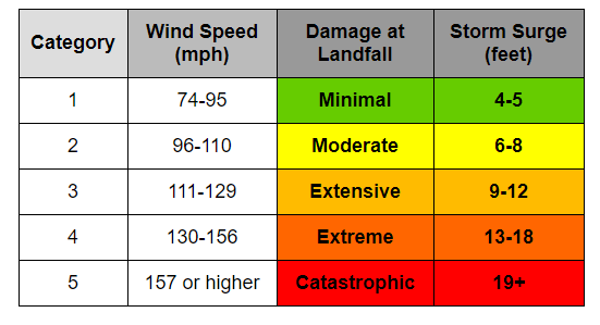 The two GOES satellites keep their eyes on hurricanes from far above Earth's surface—22,300 miles above, to be exact! (Learn more about this kind of orbit.) These satellites, built by NASA and operated by the National Oceanic and Atmospheric Administration (NOAA), save lives by helping weather forecasters predict and warn people where and when these severe storms will hit land. Shared from https://spaceplace.nasa.gov/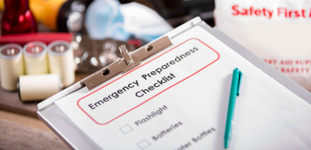 Hurricane season doesn't officially end until November 30th. As we stay on the lookout for upcoming storms, it's important to think about what to keep on hand in order to be prepared. We even wrote this handy guide to practical steps to take before or during evacuation. Even if you're not in a storm's direct path, it's worth it to keep a survival kit around and stocked in the case of tornadoes, other hurricanes, or flooding. An emergency preparedness kit can literally be life-saving—and good for peace of mind. To that end, we consulted the National Hurricane Center to see what they recommend for a basic survival kit.
Here's what they recommend you keep on hand:
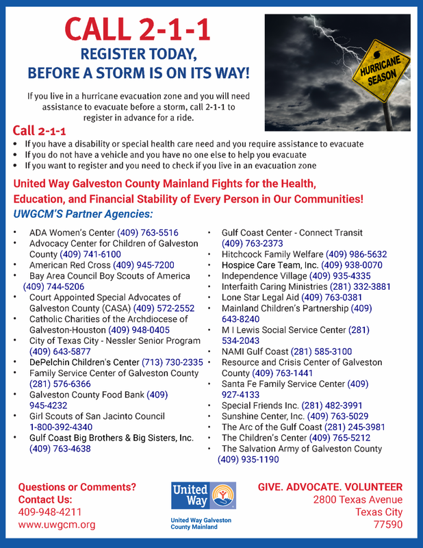
Galveston County Mainland City Offices of Emergency Management Please visit the following websites to view up to date information regarding Hurricane Season in your city and on the county level. Galveston County Office of Emergency Management Texas City Office of Emergency Management League City Office of Emergency Management La Marque Office of Emergency Management Hitchcock Office of Emergency Management Santa Fe Office of Emergency Management Dickinson Office of Emergency Management Friendswood Office of Emergency Management Power company facilities almost surely will be affected by tropical storms or hurricanes that strike their areas. The intensity and duration of a storm are key to how much impact there will be and Texas-New Mexico Power is experienced in preparing for these events. Still, it's impossible to know:
Not all customers may be affected, but they are encouraged to assume that they could be. "Our Gulf Coast teams have been through a few storms over the years," TNMP President Neal Walker says. "We can gauge our general needs for staging extra people, equipment and materials before the storm moves in. "Even with that experience and those resources, there are so many variables that we can't know what the impact could be on our facilities or our customers." Common Effects While the impact that a storm may have on our system is difficult to predict, lengthy power outages often can result. Winds can damage equipment directly, along with broken and blowing tree limbs contacting wires and other equipment. Lightning strikes also are common causes of outages. Flooding resulting from tropical storms also could impact service, including that:
If a tropical storm or hurricane is forecasted to make landfall near you:
 Translate this page into Spanish using FreeTranslation.com While forecasting methods and tools are improving year after year, people are still at great risk to tropical storms and hurricanes because they continue to build along the coastline. That is one reason for this particular web site so that people can obtain a basic understanding of hurricanes and tropical storms. The other is to provide helpful information that will help communities and their residents to prepare for these storms. The following is a list of helpful hints that you can use before hurricane season, when a watch or warning is issued, before, during, and after a tropical storm, or hurricane strikes your area.
Back To Top
Back To Top
Back To Top
Back To Top
Back To Top Preparing for a Hurricane or Tropical Storm
Español (Spanish) You can’t stop a tropical storm or hurricane, but you can take steps now to protect yourself and your family. If you live in areas at risk, the Centers for Disease Control and Prevention (CDC) encourages you to be prepared for hurricane season. The Atlantic hurricane season is June 1 through November 30 each year. It’s always important to be prepared for a hurricane. Your planning may be different this year because of the need to protect yourself and others from COVID-19. For tips to help you safely prepare, evacuate, and shelter for severe storms while protecting yourself and others from COVID-19, please see: Preparing for Hurricanes During the COVID-19 Pandemic. Preparing for a HurricaneFollow these important hurricane preparedness tips from CDC:
Preparing now can help keep you and your family safe. Staying Safe After a HurricaneIn addition to preparing for a hurricane, it’s important to take steps to stay safe after a hurricane is over, for example:
After you have read these tips, please review the other resources available on the CDC Hurricanes website. More Information
|
 RSS Feed